(Right-click on image and select 'save target as' to save map.)
NOTE: This map was constructed using the MOLA 1/32nd degree global topography map (with reference to higher resolution 1/64th degree maps), rendered using POVRay 3.02 by Constantine Thomas. The sea levels and features shown on this map and the Global Mars Map are based on accurate topographic data, and are provided as an optional replacement for the maps in ITW. However, they are NOT official, and are not canonical - they're just an option for you to use!
(Right-click on image and select 'save target as' to save map.)
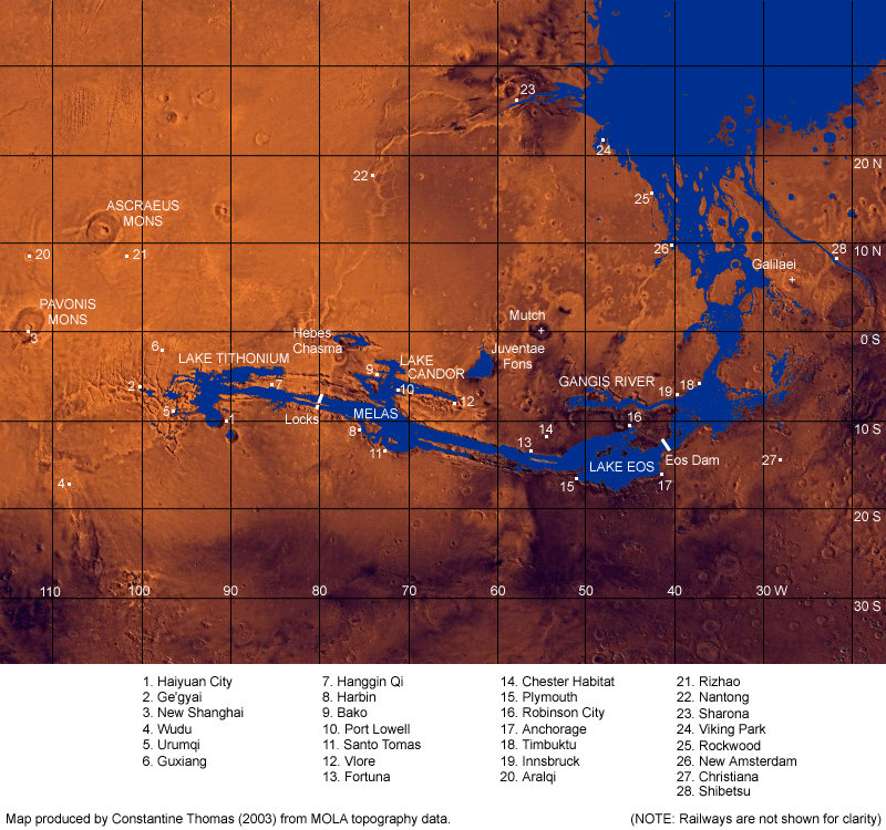
Sea level east/north of Eos Dam was set at 4.6 km above the lowest point on Mars. For the purposes of this map, this is assumed to be the sea level for the Borealis Sea. This was the lowest sea level that could flood the Chryse, Amazonis and Adamas Bays all at the same time - the shorelines on the ITW map are based on older, incorrect data.
The sea level in the Marineris between Eos and the locks (i.e. in Coprates/Melas) is set at 7.0 km above the lowest point on Mars. The seafloor to the east of the Eos Dam is about 300 metres deep, and is filled with water from the Borealis Sea. The seafloor to the west of the Eos Dam is about 3.7 km deep - so the dam is therefore about 3.8 km high from seafloor to top (giving it an extra 100m of clearance)!! It crosses at the narrowest point of that area of the Valles Marineris, and as such is about 45 km wide.
The water in Ius (west of the Giant Locks at the western end of Marineris) is at 7.5 km above the lowest point on Mars. Technically, Noctis Labyrinthis is much higher than this, but I've lowered it by about 5km so that it's level with eastern Ius. The collapse can be explained by the emptying of the giant subterranean aquifer that was melted to make the Marineris Sea. There is a height difference of 500 metres between the waters to the west of the Locks and the waters to the east. The floor of Marineris is at 4.8 km above the lowest point on Mars at the Locks - the locks are therefore 2.7 km high from seafloor to top. The lock on the northern side of the axial island is 40 km wide, while the lock on the southern side is 15 km wide.
Differences between this map and the ITW maps (ITW18-19, ITW22)